Welcome
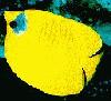
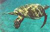
to the red sea... Here you can see images from the red sea.
The red sea is an arm of the Indian ocean which
seperates northern Africa from the Arabian peninsula. One of the warmest
seas of the world, and very saline (4%), it is 1400 miles long, up to 200
miles wide, and as much as 8000 feet deep. It is conected to the mediterranean
by the Suez canal, and to the gulf of Aden and Indian ocean by "Bab El
Mandeb" the narrow strait between Djibouti and Yemen. Since the opening
of the suez canal in 1869, the red sea has been a busy shipping lane, connecting
Europe with Asia and East Africa. It has no large port cities, because
most of the coastline is desert and the shore is lined withe the worlds
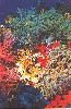
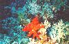
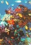
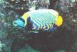
most beutiful coral reefs.
The best coral reefs could be
seen at the red sea perticulary at Hurgada, Sharm El Sheikh and Ras Muhamed.
A man-made waterway across the desert, connecting the Medeteranian with the red sea. It is one of the most important waterways in the world, because the only other route for ships between Europe and the Orient is around the southern tip of Africa, this route is not only long, but dangerous too. It is 101 miles longand 200 feet wide. The Egyptians have made it deeper and deeper since it was first dug. The journey from Port Said (northern tip) to Suez (southern tip) takes 13 hours. Special (specialists) pilots lead the ship through the canal.
The Freanch ordered the Egyptian people to dig from the Medeteranian to the "Temsah" lake, and from there to "Murah" lake, then to the Red sea... This work was under British supervision, because the Freanch wanted to make the area around the canal a Freanch province but the British wanted it for themselves. At last with the help of the United States and former Soviet Union the Freanch and British left, and the canal remained Egyptian land.. The United States was then able to get the petroleum off Saudi Arabia, Kuwait and Oman through the Suez canal.
The October '73 war -between Arabs and Israelis- was an Arab victory to most Arab countries because of the Suez canal. The Arabs stopped shipping through Suez canal and Petroleum was not passing through their so the United States didn't help the Israelis, and the price of petroleum rised, so did the price of shipping through the Suez canal. But the Golan heights, Gaza strip and West bank remained Israeli occupied territories.
1-Suez:
135 km from Cairo. A major port -after Alexandria- for Egypt. The southern tip of the Suez canal. It is a shopping area. It is a the one of two red sea port.
2-Ismailia
125 km from Cairo. Ismailia is known for it's gardens and relaxing greeness. Lake "Temsah", near the city, offers a conference centre and modern water sports facilities.
3-Port Said
120 km from Cairo. It is a quite city surounded by water. The Mediteranean is to the north, lake Manzala to the southwest, and the canal is to the east. Port Said is another shopping centre, rich in green gardens and mango plantations. The beach at Port Fouad is particulary popular. The military meseum displays relics of the battles of 1956, 1967 and 1973.